
Ugasan:As-map.png
Ndang adong resolusi natumimbo.
As-map.png (329 × 353 piksel, balga ni berkas: 21 KB, rumang na MIME: image/png)

|
This map image could be re-created using vector graphics as an SVG file. This has several advantages; see Commons:Media for cleanup for more information. If an SVG form of this image is available, please upload it and afterwards replace this template with
{{vector version available|new image name}}.
It is recommended to name the SVG file “As-map.svg”—then the template Vector version available (or Vva) does not need the new image name parameter. |
Panimpulan
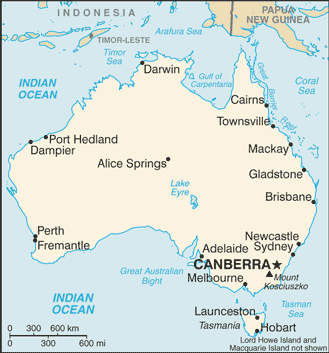
| Deskripsi |
Lëtzebuergesch: Kaart vun Australien. |
| Tanggal | 19 Juli 2007 |
| Mualna |
CIA World Factbook |
| Panompa | United States Central Intelligence Agency |
| Other versions |
|
.png)
Ragam ni lisensi
This image is in the public domain because it contains materials that originally came from the United States Central Intelligence Agency's World Factbook.
|
 |
Jujur ni ugasan
Piltik di sada tanggal/pukul laho mangida ugasan on di tingki i.
| Tanggal/Pukul | Metmetna | Dimensi | Sipanghasea | Hata panambai | |
|---|---|---|---|---|---|
| saonari | 23:48, 28 Januari 2009 | | 329 × 353 (21 KB) | DaniDF1995 | Reverted to version as of 16:48, 28 January 2009 |
| 23:48, 28 Januari 2009 |  | 329 × 386 (20 KB) | DaniDF1995 | Some fix | |
| 23:48, 28 Januari 2009 |  | 329 × 353 (21 KB) | DaniDF1995 | Reverted to version as of 16:46, 28 January 2009 | |
| 23:47, 28 Januari 2009 |  | 329 × 386 (20 KB) | DaniDF1995 | Some fix | |
| 23:46, 28 Januari 2009 |  | 329 × 353 (21 KB) | DaniDF1995 | Reverted to version as of 09:57, 25 July 2007 | |
| 23:45, 28 Januari 2009 |  | 329 × 386 (20 KB) | DaniDF1995 | Some fix | |
| 16:57, 25 Juli 2007 |  | 329 × 353 (21 KB) | Hoshie | Updated map of Australia from the CIA World Factbook, 19 July 07 rev. Src: https://www.cia.gov/library/publications/the-world-factbook/maps/as-map.gif | |
| 22:07, 26 Pebruari 2005 |  | 328 × 352 (13 KB) | Alfio | CIA map of Australia |
Parhaseangon ni ugasan
alaman pangait tu alualu on:
Parhaseangon ugasan na global
Wiki na asing manghaseanghon ugasan on:
- Parhaseangon di ab.wikipedia.org
- Parhaseangon di af.wikipedia.org
- Parhaseangon di arz.wikipedia.org
- Parhaseangon di azb.wikipedia.org
- Parhaseangon di bg.wikipedia.org
- Parhaseangon di bh.wikipedia.org
- Parhaseangon di bjn.wikipedia.org
- Parhaseangon di bn.wikipedia.org
- Parhaseangon di ca.wikipedia.org
- Parhaseangon di ckb.wikipedia.org
- Parhaseangon di cs.wikipedia.org
- Parhaseangon di cv.wikipedia.org
- Parhaseangon di da.wikipedia.org
- Parhaseangon di de.wikinews.org
- Parhaseangon di dsb.wikipedia.org
- Parhaseangon di dty.wikipedia.org
- Parhaseangon di en.wikipedia.org
- List of cities in Australia
- Wikipedia talk:WikiProject Countries/Proposal 1
- Trans Australia Airlines Flight 538
- User:Peursem
- Outline of Australia
- Wikipedia:Recent additions/2004/April
- Module:Location map/data/Australia/doc
- User talk:Nil Einne
- Module:Location map/data/Australia
- North Australian Basin
- Parhaseangon di en.wikibooks.org
- Parhaseangon di en.wikinews.org
- Parhaseangon di eo.wikipedia.org
- Parhaseangon di es.wikipedia.org
- Parhaseangon di fa.wikipedia.org
- Parhaseangon di fi.wikipedia.org
- Parhaseangon di fi.wikinews.org
- Parhaseangon di fo.wikipedia.org
- Parhaseangon di fr.wikipedia.org
Ida lumobi godangan pamangke global sian ugasan on.