
Ugasan:Indonesia, administrative divisions - en - monochrome.svg

Size of this PNG preview of this SVG file: 800 × 367 piksel. Na asing angka resolusi: 320 × 147 piksel | 640 × 293 piksel | 1,024 × 469 piksel | 1,280 × 587 piksel | 2,560 × 1,173 piksel | 982 × 450 piksel.
Ungkuran na tingkos (Berkas SVG, nominal 982 × 450 piksel, balga ni surat partadingan: 909 KB)
| Deskripsi |
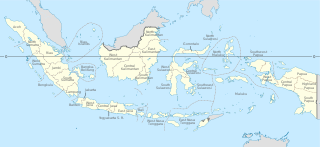
English: Indonesia provinces map (in Malgache)
Français : Carte des provinces indonésiennes (en malgache) Deutsch: Karte der indonesischen Provinzen Malagasy : Saritanin'ny faritany indonezianina (amin'ny fiteny malagasy) |
||||
| Tanggal | (UTC) | ||||
| Mualna | |||||
| Panompa |
|
||||
| Other versions |
|
||||
| SVG genesis |
|


Ugasan on isinna i ma di bagasan Creative Commons Attribution-Share Alike 3.0 Unported.
- Boi do hamu:
- marbagi – Mangganti dohot paserakhon muse angkup ni tulisan on ni bagas rumang manang aha pe
- mangose – Mangadaptasi sikarejoan on
- Marbingkas hatontuon marihut
- atribusi – Ingkon dibahen hamu do panjangkonon na une, mangalehon pangait tu pasiathon jala paboahon manang adong hamubaon. Boi do dibahen hamu marhitehite dalan na pinillit ni hamu sandiri, alai ndang manatahon ala na mangalehon pasiat surat isin na mangalophon hamu manang pambahenan ni hamuna
- marsagi tudos – Molo naeng manguba manang mambahen na asing sian guritan on, hamu ingkon pararathon pambahenanmuna i di toru ni same or compatible license songon asli na.
Original upload log
This image is a derivative work of the following images:
- File:Indonesia, administrative divisions - mg - monochrome.svg licensed with Cc-by-sa-3.0,2.5,2.0,1.0, GFDL
- 2010-02-04T05:32:46Z Queix 1322x620 (326516 Bytes) Modifying of foreign area's castline
- 2010-02-03T18:37:53Z Queix 1322x620 (325080 Bytes) {{Information |Description={{en|1=Indonesia provinces map (in French)}} {{fr|1=Carte des provinces indonésiennes (en français)}} |Source=*[[:File:Indonesia_provinces_map-fr.svg|]] |Date=2010-02-03 18:34 (UTC) |Author=*[[:Fi
- 2010-02-02T21:42:13Z Queix 1322x620 (319665 Bytes) '
- 2010-02-02T21:32:37Z Queix 1322x620 (319755 Bytes) '
- 2010-02-02T21:29:23Z Queix 1322x620 (319852 Bytes) '
- 2010-02-02T18:56:04Z Queix 1322x620 (319689 Bytes) {{Information |Description={{en|1=Indonesia provinces map (in Malgache)}} {{fr|1= Carte des provinces indonésiennes (en malgache)}} |Source=Travail personnel (own work) |Author=Sardon |Date=02/02/2010 |Permission= |other_ver
- File:Indonesia_provinces_english.png licensed with Cc-by-2.5, Cc-by-sa-3.0-migrated, GFDL
- 2006-01-08T07:54:20Z Golbez 1500x590 (78783 Bytes) Map of the provinces of Indonesian in English. Made by [[User:Golbez]] based on a PD CIA map, using other sources to guesstimate the extent of West Irian Jaya and West Sulawesi. [[Category:Maps of Indonesia]]
Uploaded with derivativeFX
Jujur ni ugasan
Piltik di sada tanggal/pukul laho mangida ugasan on di tingki i.
| Tanggal/Pukul | Metmetna | Dimensi | Sipanghasea | Hata panambai | |
|---|---|---|---|---|---|
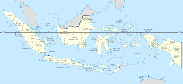
| saonari | 23:09, 4 Desember 2022 | | 982 × 450 (909 KB) | NordNordWest | adding Southwest Papua |
| 10:03, 21 Agustus 2022 |  | 982 × 450 (737 KB) | Afrogindahood | Addition of new provinces in Western New Guinea | |
| 16:04, 24 Juli 2022 |  | 982 × 450 (954 KB) | Qexypnos | Reverted to version as of 21:38, 14 August 2021 (UTC) | |
| 03:43, 23 Juli 2022 |  | 2,560 × 1,170 (824 KB) | Qexypnos | map correction | |
| 03:34, 23 Juli 2022 |  | 2,560 × 1,170 (824 KB) | Qexypnos | added provinces of Highland Papua, South Papua, Central Papua | |
| 04:38, 15 Agustus 2021 |  | 982 × 450 (954 KB) | Afrogindahood | Minor resolution readjustment | |
| 20:47, 22 Oktober 2020 |  | 786 × 360 (731 KB) | Afrogindahood | Addition of North Kalimantan province | |
| 20:48, 21 Januari 2011 |  | 1,322 × 620 (318 KB) | Yug | Font size | |
| 20:33, 21 Januari 2011 |  | 1,322 × 620 (319 KB) | Yug | bug fix trial 4 | |
| 20:30, 21 Januari 2011 |  | 1,322 × 620 (319 KB) | Yug | buf fix trial 3 |
Parhaseangon ni ugasan
2 angka alaman na marpangait tu alualu on:
Parhaseangon ugasan na global
Wiki na asing manghaseanghon ugasan on:
- Parhaseangon di ace.wikipedia.org
- Parhaseangon di an.wikipedia.org
- Parhaseangon di ar.wikipedia.org
- Parhaseangon di ban.wikipedia.org
- Parhaseangon di bg.wikipedia.org
- Parhaseangon di bn.wikipedia.org
- Parhaseangon di bs.wikipedia.org
- Parhaseangon di cs.wikipedia.org
- Parhaseangon di en.wikipedia.org
- Parhaseangon di frp.wikipedia.org
- Parhaseangon di he.wikipedia.org
- Parhaseangon di id.wikipedia.org
- Parhaseangon di id.wikibooks.org
- Parhaseangon di ja.wikipedia.org
- Parhaseangon di lt.wikipedia.org
- Parhaseangon di mg.wikipedia.org
- Parhaseangon di pt.wikipedia.org
- Parhaseangon di ro.wikipedia.org
- Parhaseangon di simple.wikipedia.org
- Parhaseangon di sq.wikipedia.org
- Parhaseangon di tl.wikipedia.org
- Parhaseangon di tr.wikipedia.org
- Parhaseangon di uk.wikipedia.org
- Parhaseangon di vec.wikipedia.org
- Parhaseangon di vi.wikipedia.org
- Parhaseangon di zh.wikipedia.org