
Ugasan:Kansai closeup.jpg
Ndang adong resolusi natumimbo.
Kansai_closeup.jpg (800 × 600 piksel, balga ni berkas: 66 KB, rumang na MIME: image/jpeg)
Panimpulan
| Deskripsi |
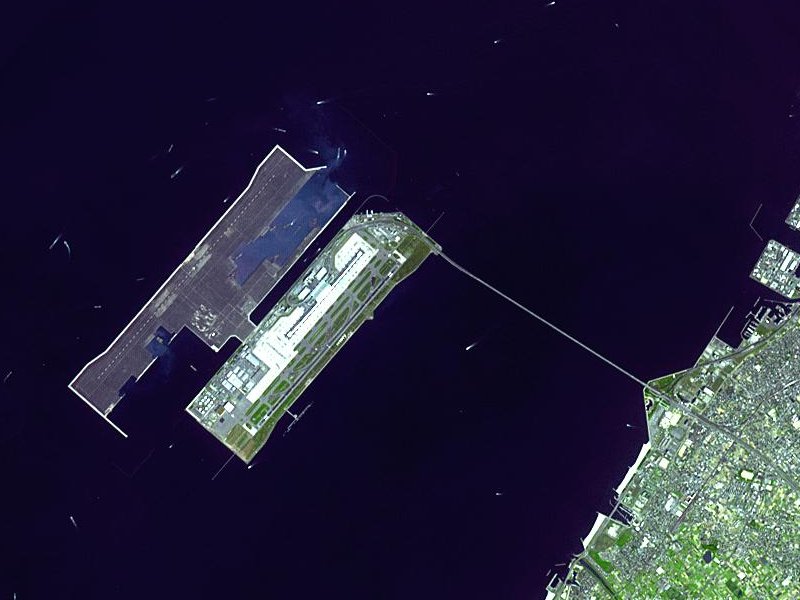
Satellite image of Kansai International Airport in Osaka Bay in Japan. This is a closeup - for an overview image showing the airport on its artificial island in the bay, see Image:Wfm kansai overview.jpg |
| Tanggal | |
| Mualna |
Taken from an uncopyrighted image NASA Earth Observatory |
| Panompa | NASA Earth Observatory |
| Loas (Parhaseanghon muse ugasan on) |
"The purpose of NASA's Earth Observatory is to provide a freely-accessible publication on the Internet where the public can obtain new satellite imagery and scientific information about our home planet. The focus is on Earth's climate and environmental change. In particular, we hope our site is useful to public media and educators. Any and all materials published on the Earth Observatory are freely available for re-publication or re-use, except where copyright is indicated. We ask that NASA's Earth Observatory be given credit for its original materials." |
| Other versions |

| Object location | | View this and other nearby images on: OpenStreetMap |
|---|
Ragam ni lisensi
| This file is in the public domain in the United States because it was solely created by NASA. NASA copyright policy states that "NASA material is not protected by copyright unless noted". (See Template:PD-USGov, NASA copyright policy page or JPL Image Use Policy.) | ||
 |
Warnings:
|
en.Wikipedia upload log
The en.Wikipedia description page is/was here. All following user names refer to en.Wikipedia.
- 2004-04-05 19:30 Finlay McWalter 800×600 (66 KB) (nasa image of kansai airport)
Jujur ni ugasan
Piltik di sada tanggal/pukul laho mangida ugasan on di tingki i.
| Tanggal/Pukul | Metmetna | Dimensi | Sipanghasea | Hata panambai | |
|---|---|---|---|---|---|
| saonari | 10:46, 13 Desember 2005 | | 800 × 600 (66 KB) | Sam916~commonswiki | Satellite image of Kansai International Airport in Osaka Bay in Japan. This is a closeup - for an overview image showing the airport on its artificial island in the bay, see Image:Wfm kansai overview.jpg Taken from an uncopyrighted imag |
Parhaseangon ni ugasan
alaman pangait tu alualu on:
Parhaseangon ugasan na global
Wiki na asing manghaseanghon ugasan on:
- Parhaseangon di ar.wikipedia.org
- Parhaseangon di ast.wikipedia.org
- Parhaseangon di bg.wikipedia.org
- Parhaseangon di bh.wikipedia.org
- Parhaseangon di bn.wikipedia.org
- Parhaseangon di de.wikipedia.org
- Parhaseangon di el.wikipedia.org
- Parhaseangon di en.wikipedia.org
- Parhaseangon di en.wikibooks.org
- Parhaseangon di es.wikipedia.org
- Parhaseangon di eu.wikipedia.org
- Parhaseangon di fa.wikipedia.org
- Parhaseangon di fi.wikipedia.org
- Parhaseangon di he.wikipedia.org
- Parhaseangon di hu.wikipedia.org
- Parhaseangon di id.wikipedia.org
- Parhaseangon di io.wikipedia.org
- Parhaseangon di it.wikipedia.org
- Parhaseangon di it.wikivoyage.org
- Parhaseangon di ja.wikipedia.org
- Parhaseangon di ko.wikipedia.org
- Parhaseangon di lfn.wikipedia.org
- Parhaseangon di ml.wikipedia.org
- Parhaseangon di mn.wikipedia.org
- Parhaseangon di ms.wikipedia.org
- Parhaseangon di nl.wikipedia.org
- Parhaseangon di pt.wikipedia.org
- Parhaseangon di ro.wikipedia.org
- Parhaseangon di simple.wikipedia.org
- Parhaseangon di sl.wikipedia.org
- Parhaseangon di sr.wikipedia.org
- Parhaseangon di sv.wikipedia.org
- Parhaseangon di ta.wikipedia.org
- Parhaseangon di uk.wikipedia.org
- Parhaseangon di vi.wikipedia.org
- Parhaseangon di www.wikidata.org
- Parhaseangon di zh-yue.wikipedia.org
- Parhaseangon di zh.wikipedia.org
Ida lumobi godangan pamangke global sian ugasan on.