
Ugasan:Oceania UN Geoscheme Regions.svg

Size of this PNG preview of this SVG file: 800 × 462 piksel. Na asing angka resolusi: 320 × 185 piksel | 640 × 370 piksel | 1,024 × 592 piksel | 1,280 × 740 piksel | 2,560 × 1,479 piksel | 900 × 520 piksel.
Ungkuran na tingkos (Berkas SVG, nominal 900 × 520 piksel, balga ni surat partadingan: 128 KB)
Panimpulan
This W3C-unspecified vector image was created with Adobe Illustrator.
| Deskripsi |
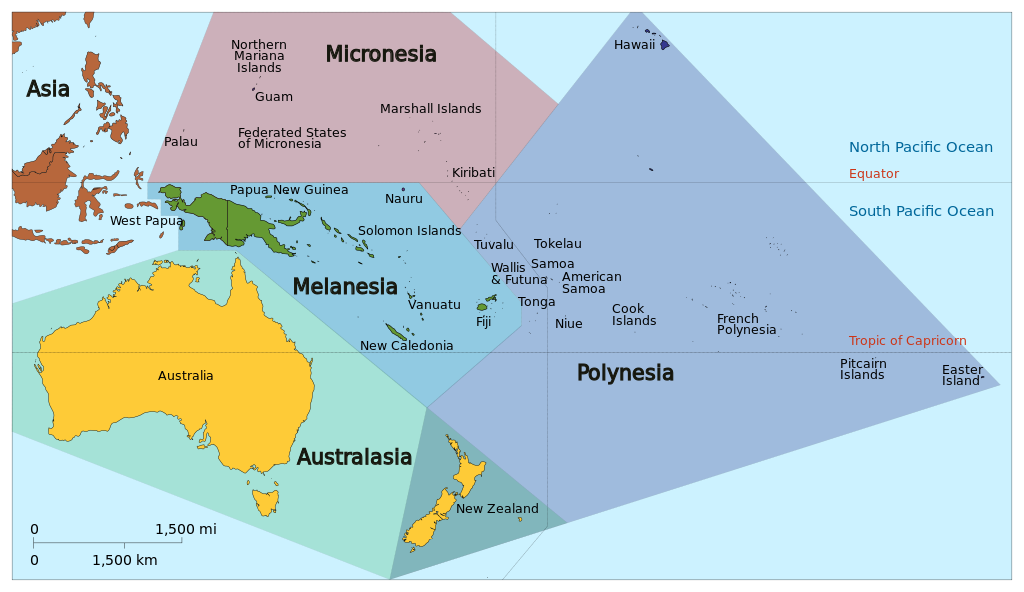
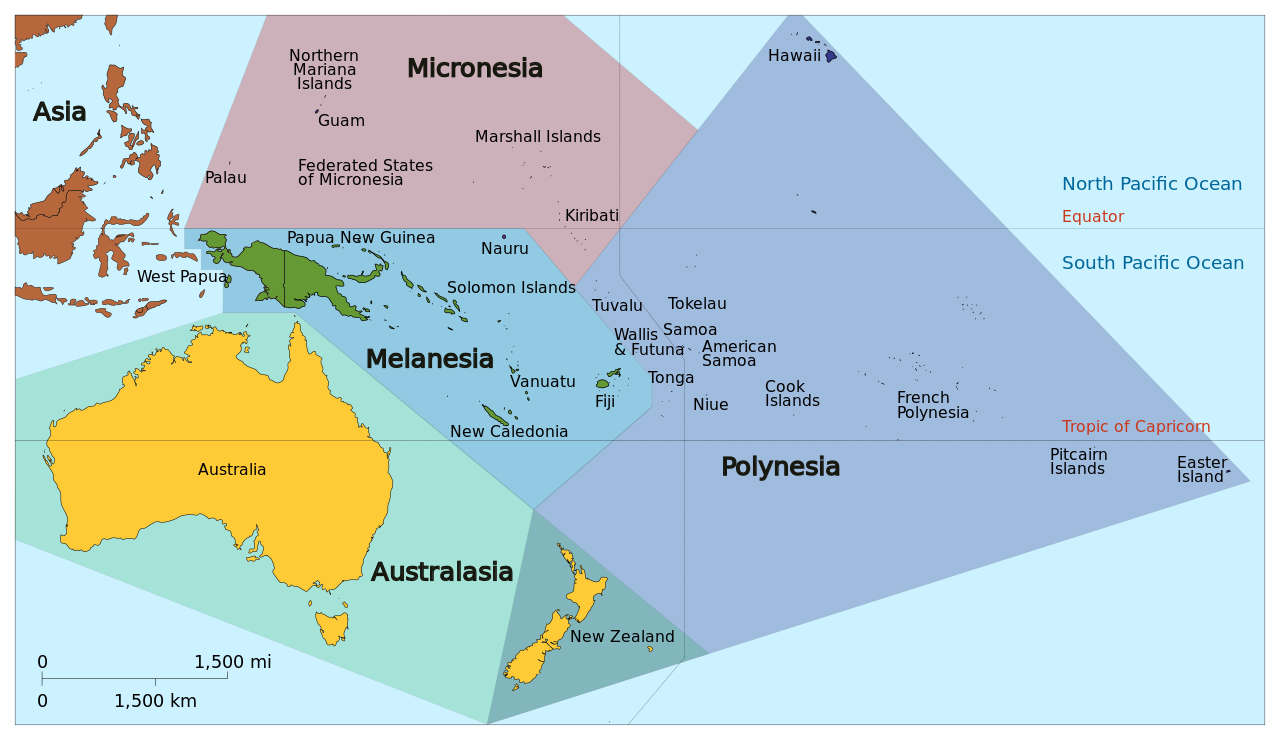
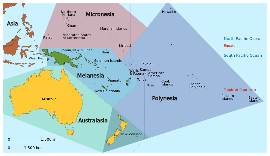
English: Map of Oceania based on the United Nations geoscheme M49 coding classification devised by the United Nations Statistics Division. Exceptions: New Zealand shown in both Australia (as per UN geozones) as well as Polynesia and so needs a qualifier description on any Wiki article; Hawaii and Easter Island shown which belong to USA and Chile in the 'Americas' geozone. SVG format. |
| Tanggal | |
| Mualna | Ulaon sandiri, derivative of Oceania_ISO_3166-1.svg |
| Panompa |
|
| Other versions |
|


Ragam ni lisensi
I, the copyright holder of this work, hereby publish it under the following license:
Ugasan on isinna i ma di bagasan Creative Commons Attribution-Share Alike 3.0 Unported.
- Boi do hamu:
- marbagi – Mangganti dohot paserakhon muse angkup ni tulisan on ni bagas rumang manang aha pe
- mangose – Mangadaptasi sikarejoan on
- Marbingkas hatontuon marihut
- atribusi – Ingkon dibahen hamu do panjangkonon na une, mangalehon pangait tu pasiathon jala paboahon manang adong hamubaon. Boi do dibahen hamu marhitehite dalan na pinillit ni hamu sandiri, alai ndang manatahon ala na mangalehon pasiat surat isin na mangalophon hamu manang pambahenan ni hamuna
- marsagi tudos – Molo naeng manguba manang mambahen na asing sian guritan on, hamu ingkon pararathon pambahenanmuna i di toru ni same or compatible license songon asli na.
Jujur ni ugasan
Piltik di sada tanggal/pukul laho mangida ugasan on di tingki i.
| Tanggal/Pukul | Metmetna | Dimensi | Sipanghasea | Hata panambai | |
|---|---|---|---|---|---|
| saonari | 03:03, 18 Januari 2024 | | 900 × 520 (128 KB) | Theklan | File uploaded using svgtranslate tool (https://svgtranslate.toolforge.org/). Added translation for eu. |
| 17:36, 29 September 2017 |  | 900 × 520 (119 KB) | Cruickshanks | Corrected spelling 'Kirabati' to 'Kiribati'. | |
| 17:22, 29 September 2017 |  | 900 × 520 (520 KB) | Cruickshanks | Reverted to version as of 04:17, 30 January 2014 (UTC) - puzzled ... seemingly wrong revision just uploaded | |
| 17:13, 29 September 2017 |  | 900 × 520 (117 KB) | Cruickshanks | Corrected spelling 'Kirabati' to 'Kiribati'. Note: this is a derivative image and this correction does not correct the spelling error in the parent image. | |
| 11:17, 30 Januari 2014 |  | 900 × 520 (520 KB) | Cruickshanks | User created page with UploadWizard |
Parhaseangon ni ugasan
alaman pangait tu alualu on:
Parhaseangon ugasan na global
Wiki na asing manghaseanghon ugasan on:
- Parhaseangon di ast.wikipedia.org
- Parhaseangon di bn.wikipedia.org
- Parhaseangon di en.wikipedia.org
- History of Oceania
- Oceania
- User:Dimadick
- Lists of hospitals in Oceania
- User:GwydionM
- Wikipedia:Userboxes/Location
- Wikipedia:Userboxes/Location/Oceania
- Category:Wikipedians in Oceania
- User:Limetom
- User:ThirdEchelon
- United Nations geoscheme
- United Nations geoscheme for Oceania
- Wikipedia:Userboxes/Travel
- User:Buaidh/Test4
- User:Jun Nijo
- Category:Wikipedians interested in Oceania
- Template:User interest Oceania
- Template:User interest Oceania/doc
- User:Vmzp85
- Template:User visited Oceania
- User:Wugu
- User:PrototypePHX
- User:Wabba The I/Userboxes
- User:Guoruei
- Wikipedia:WikiProject Oceania
- Category:WikiProject Oceania participants
- List of Oceanian species extinct in the Holocene
- User:Qunty
- User:Danimations
- User:Tobermory Womble
- User:Cruickshanks/sandbox3
- User:Skinnytony1
- User:Qatagorical
- User:Scherbenmeer
- User:Turfel
- User:Cieart
- Wikipedia:Userboxes/Life/Origin
- Wikipedia:Userboxes/Life/Residence
- User:Arthurteb303
- User:Fork99
- User:Zhouchengbin
- Template:User Oceania/doc1
- Template:User in Oceania
- Template:User in Oceania/doc
- Template:User from Oceania
- Template:User from Oceania/doc
- Template:User visited Oceania/doc
Ida lumobi godangan pamangke global sian ugasan on.